Sydney Airport Message Board Sydney Airport Message Board  

Go Back   Sydney Airport Message Board > Technical > Flying and Technical Discussion
Register FAQ Calendar Today's Posts Search


Reply
 
Thread Tools Search this Thread Display Modes
  #1  
Old 15th January 2011, 11:56 PM
Brendan Lawrence's Avatar
Brendan Lawrence Brendan Lawrence is offline
Member
 
Join Date: Mar 2008
Location: Melbourne
Posts: 112
Default 'NearMap.com' - higher res than Google Earth

Just thought I'd share with you, for those who haven't heard or come across this yet; nearmap.com... It is an Australian-based online mapping company that boasts five-times the resolution of the imagery found on Google Earth/Maps. The detail is amazing. You can make out whether your car is in your driveway or not!

And having a look at Sydney and Melbourne airports you can certainly notice the difference! Here are a few screenshots I've taken as an example, but have a look at the site for yourself - they're crystal clear, zoomed right in...

Bit of a size comparison: A380 (which looks like it's right on pushback - aerobridges withdrawn / tug in place) vs B747


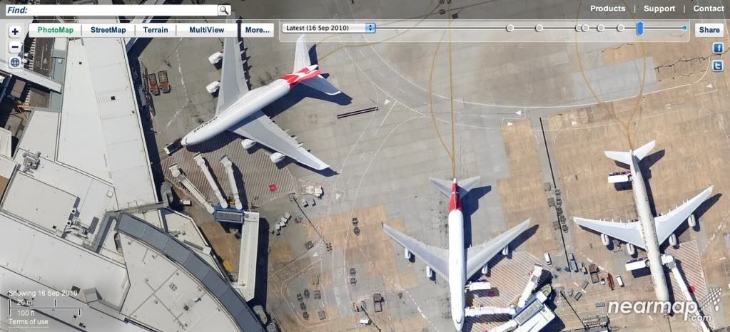
A lineup showing the length of the B777-300ER and A340-600 side by side


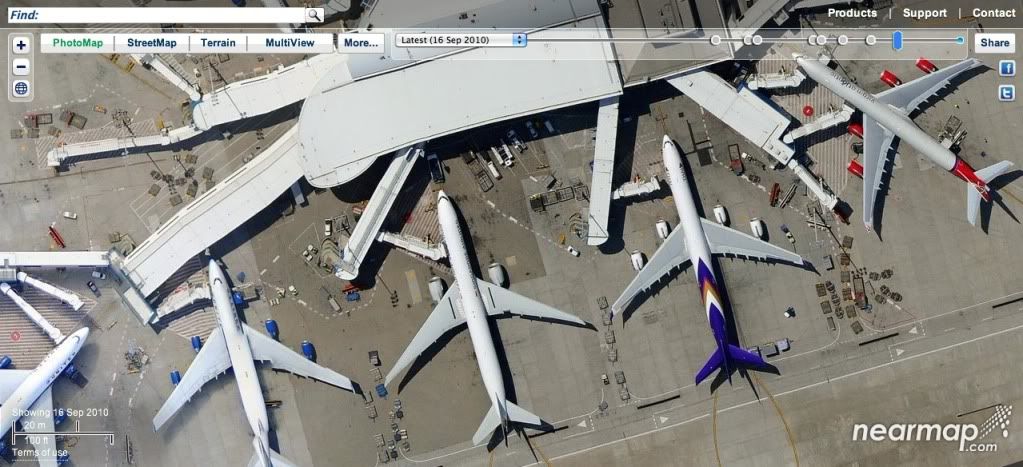
And this is T2 at Melbourne Airport with a slightly angled view, available by clicking on the 'Multi-view' tab


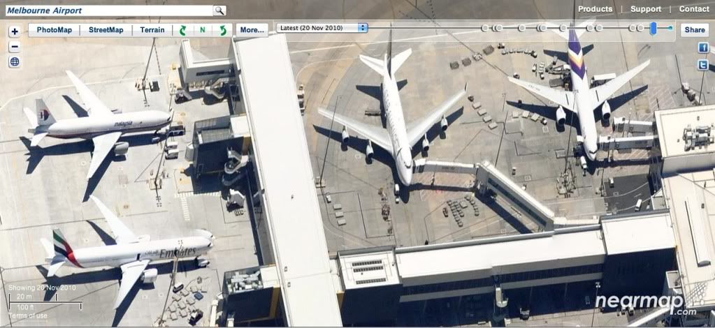
You can also select dates further back in time when the imagery was taken to watch construction of certain things taking place, etc. They have also uploaded the latest aerial view of Brisbane showing flood-affected areas, at the request of the Queensland authorities, to help with identifying the most flood-stricken areas.
Reply With Quote
  #2  
Old 16th January 2011, 09:41 AM
Kent Broadhead Kent Broadhead is offline
Member
 
Join Date: Mar 2008
Location: Dulwich Hill
Posts: 552
Default

The Google pictures of my place are from Jan/Feb 2007, Nearmap is Sept 2010 and higher resolution - much, much better!!!!! Also 4 other dates newer than Google.....
Reply With Quote
  #3  
Old 16th January 2011, 09:51 AM
Dan Collins Dan Collins is offline
Member
 
Join Date: Aug 2008
Location: Western Sydney
Posts: 233
Default

Nearmap's great! I was introduced by a friend and never looked back. They also update via Twitter for those interested - @NearMap.

I've been able to get aerial views of our house under construction due to their archived dates, and the higher resolution makes it so much better than Google Maps.

They also mapped out the recent floods in Wagga Wagga and Brisbane - the Brisbane ones became viewable yesterday.

Dan
__________________
twitter.com/dshibi :: twitter.com/abraxasvideo :: youtube.com/abraxasvideo :: facebook.com/abraxasvideo

04/09/14 QF129 SYD-PVG A333 VH-QPG :: 08/09/14 CX367 PVG-HKG 77W B-KQO :: 13/09/14 QF128 HKG-SYD A388 VH-OQH
29/09/14 QF556 SYD-BNE 763ER VH-OGO :: 30/09/14 QF008 BNE-SYD 744ER VH-OEG
Reply With Quote
  #4  
Old 16th January 2011, 07:10 PM
Brad M Brad M is offline
Member
 
Join Date: May 2008
Posts: 80
Default

excellent..
Adelaide airport photo is very recent.. with all the new remote bay layouts at T2 with the Malaysia 772 on bay 82 , and with all the building demolition in progress currently..
Reply With Quote
  #5  
Old 16th January 2011, 11:08 PM
Nathan Bartlett Nathan Bartlett is offline
Member
 
Join Date: Jul 2009
Posts: 59
Default

Pretty cool i think! My favourite so far!

http://www.nearmap.com/?q=@-32.04692...n&nmd=20100529
Reply With Quote
  #6  
Old 17th January 2011, 11:55 AM
Brock Little's Avatar
Brock Little Brock Little is offline
Member
 
Join Date: Jul 2010
Location: Gold Coast, Australia
Posts: 484
Default

And how did you manage to find that?!
__________________
Photos

JetPhotos.net (1381 Photos)
Reply With Quote
  #7  
Old 17th January 2011, 12:24 PM
Nathan Long Nathan Long is offline
Member
 
Join Date: Mar 2008
Location: YMML
Posts: 263
Default

The middle of a paddock near Perth?

Very interesting...

Ah, now I see. The link was showing something else at work...
__________________
My JetPhotos photos
All Australia Canada NZ UK
Reply With Quote
  #8  
Old 17th January 2011, 07:18 PM
Robert S Robert S is offline
Member
 
Join Date: Mar 2008
Location: Sydney
Posts: 283
Default

Quote:
Originally Posted by Nathan Bartlett View Post
Pretty cool i think! My favourite so far!

http://www.nearmap.com/?q=@-32.04692...n&nmd=20100529
It's worth maximising your window when looking at that...
Reply With Quote
  #9  
Old 17th January 2011, 09:12 PM
Jack B Jack B is offline
Member
 
Join Date: Oct 2008
Posts: 422
Default

Excellent stuff! Thanks for sharing Brendan!
Reply With Quote
  #10  
Old 17th January 2011, 11:53 PM
Philip Argy's Avatar
Philip Argy Philip Argy is offline
Senior Member
 
Join Date: May 2008
Location: North Strathfield
Posts: 1,402
Smile There are how many Gladesville Bridges?

Quote:
Originally Posted by Nathan Bartlett View Post
Pretty cool i think! My favourite so far!

http://www.nearmap.com/?q=@-32.04692...n&nmd=20100529
And a neat trick: drag the nose of the a/c off the bottom right of your screen until the next image of the same aircraft appears further down its approach path. If you then do that once more the a/c appears to crash where two images have been spliced!

Nearmap does have excellent resolution, though.

For another optical illusion check out the South facing MultiView of Gladesville Bridge as at 16 Sep 2010.
__________________
Philip
Reply With Quote
Reply


Posting Rules
You may not post new threads
You may not post replies
You may not post attachments
You may not edit your posts

BB code is On
Smilies are On
[IMG] code is On
HTML code is Off

Forum Jump


All times are GMT +10. The time now is 05:37 PM.


Powered by vBulletin® Version 3.8.11
Copyright ©2000 - 2024, vBulletin Solutions Inc.
Copyright © Sydney Airport Message Board 1997-2022
Use of this web site constitutes acceptance of the Conditions of Use and Privacy Statement