
 |
 |
|
#1
|
|||
|
|||
|
I was searching around today to try and find a live broadcast for a Sydney radar but had trouble locating one that is active. Does anybody have a link to a site that broadcasts live radar?
I saw first hand on the weekend one of those Kinetic Avionics SBS transponders linked to a laptop tracking real-time but haven't found anybody sending that data live to the web for the public to view. |
|
#2
|
|||
|
|||
|
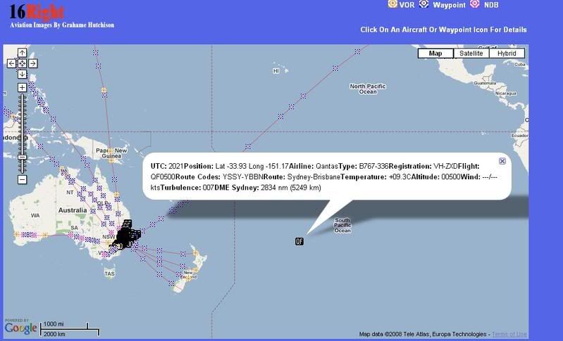
There is the 16right.com acars google maps, but its not as good as a radar would be.
Incidentally... QF don't seem too worried about fuel prices  
|
|
#3
|
|||
|
|||
|
There is a site called Planeplotter that broadcasts via the web real time radar returns . It can be found at http://www.coaa.co.uk/planeplotter.htm..
Here is a screen shot taken just a few minutes ago of the YSSY area . Not very busy though .  Dave C |
|
#4
|
||||
|
||||
|
Hi Rhys, now and then the ACARS transmissions are corrupted by weather conditions etc. and an aircraft appears in strange locations.
This example would be a great flight from Sydney to Brisbane at 500ft.
__________________
Joined 1999 @www16Right FlightDiary Airliners Web QR Retired PPL C150/172 PA28-161/181 Pitts S-2B SIM: 12Hr QF B767 B744 CX B742 Nikon D100-D200-D300-D500 |
|
#5
|
|||
|
|||
|
Quote:

|
|
#6
|
|||
|
|||
|
Planeplotter is exactly what I am after. It will do until I can spare the $1,000 to buy my own transponder from Kinetics.
|
|
#7
|
|||
|
|||
|
Glad I could be of help... Planeplotter is fantastic , I guarantee that you won't bother spending your $1000 when you can fully use PP . Enjoy ..
Dave C |
|
#8
|
|||
|
|||
|
I am just trying to get my head around how to get Planeplotter to work. Not quite sure where to start........ I think I need to download maps of Sydney etc and I have no clue to to connect it to an online source. Lots of reading coming my way.
|
|
#9
|
||||
|
||||
|
Hello NickN, the Kinetic SBS-1 unit processes the ADS-B and ModeS radio transmissions from those aircraft so equipped and places the info into a Kinetic software program called BaseStation. BaseStation then displays the aircraft's position, altitude, direction and speed on an outline of the area of your interest. You can download or draw up outlines and waypoints to suit your own needs. Theres are a number of SBS-1 users located around Australia who, I'm sure, will be willing to help you out with maps of your area.
PlanePlotter is a separate program that takes that same info from the SBS-1 and again displays the information on a satellite image or Google Earth. There is no real advantage running BaseStation along side PlanePlotter because you see the same details. However, what is so great about PlanePlotter that you can share your plots with other sharers around the world and in turn see their plots. While the SBS-1 unit is not cheap, BaseStation is free and is under further development with many add-on program which makes it a fascinating hobby. PlanePlotter costs a one off fee of 25 Euros and the developer, an Australian, working from Portugal is constantly updating the program 2 to 3 times a month. There are group of Australian PP sharers feeding their plots covering the populated areas from far North Queensland right around the coast (including Tassie) all the way to Perth. Depending on their locations and how high their antennas are, could have a range as good as 200nm. The ADS-B transmissions are in the 1090Mhz band and are very line of sight so hills, trees buildings etc., tend to block some of the data. So if you don't want to part with your hard earned dollars for a SBS unit, you only need to download PlanePlotter, pay your licence fee and watch the world's sky open up from of the comfort of your lounge room.
__________________
Cheers, Noel White |
|
#10
|
|||
|
|||
|
Noel awesome info!!
I am just trying to figure out how to get my PlanePlotter to receive other peoples data relays and get the right maps set up. |
 |
|
|